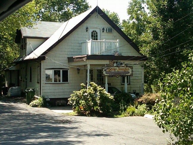
Property Record
144 Harding Ave, Edison, NJ 08820
NEARBY LISTINGS FOR SALE OR LEASE
Property Detail
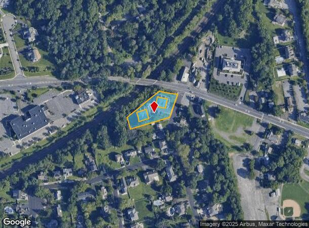
144 Harding Ave
New York-Jersey City-White Plains, NY-NJ
Oak Tree Terrace
05-00556-03-00006-02
75X222 53X272 IRR COMMON ELEMENT
Taxexempt
Middlesex
X
New Jersey
34023C0034F
6.2
0
0.66 AC
2025
South Edison
001415
Northern New Jersey
1,494 SF
DEMOGRAPHICS near 144 Harding Ave
1 Mile
3 Mile
5 Mile
2024 Total Population
8,351
107,001
362,239
2029 Population
8,346
106,357
359,501
Pop Growth 2024-2029
(0.06%)
(0.60%)
(0.76%)
Average Age
42
41
40
2024 Total Households
2,667
35,611
121,674
HH Growth 2024-2029
(0.15%)
(0.69%)
(0.80%)
Median Household Inc
$156,967
$129,031
$109,880
Avg Household Size
3.00
2.90
2.90
2024 Avg HH Vehicles
2.00
2.00
2.00
Median Home Value
$503,095
$475,840
$423,273
Median Year Built
1977
1970
1963
Nearby Places
Map Layers
Map Styles
 Street
 Aerial
- Restaurants
- Banks
- Shops
- Fitness
- Groceries
PUBLIC TRANSPORTATION
COMMUTER RAIL
Metuchen (Northeast Corridor Line - NJ Transit Commuter Rail (NJ Transit))
DRIVE
WALK
Distance
Metuchen (Northeast Corridor Line - NJ Transit Commuter Rail (NJ Transit))
7 min
3.2 mi
Metropark (Northeast Corridor Line - NJ Transit Commuter Rail (NJ Transit))
DRIVE
WALK
Distance
Metropark (Northeast Corridor Line - NJ Transit Commuter Rail (NJ Transit))
6 min
3.2 mi
AIRPORT
Newark Liberty International
DRIVE
WALK
Distance
Newark Liberty International
28 min
20.9 mi
Freight Ports
New York Container Terminal
DRIVE
WALK
Distance
New York Container Terminal
27 min
17.5 mi
SALE & LEASE HISTORY
LISTING DATE
SALE/LEASE

Sep 23, 2016
For Sale
Nearby Properties
Address
Land Use
TOTAL SIZE
Lot Size
Zoning
Address
Land Use
TOTAL SIZE
Lot Size
Zoning
37.46 AC
EI
Address
Land Use
TOTAL SIZE
Lot Size
Zoning
80,000 SF
23.37 AC
R50
Address
Land Use
TOTAL SIZE
Lot Size
Zoning
137.89 AC
RAA
Address
Land Use
TOTAL SIZE
Lot Size
Zoning
96.22 AC
RA
Address
Land Use
TOTAL SIZE
Lot Size
Zoning
5,645 SF
91.16 AC
O
Address
Land Use
TOTAL SIZE
Lot Size
Zoning
3.18 AC
Address
Land Use
TOTAL SIZE
Lot Size
Zoning
30.80 AC
R10
Address
Land Use
TOTAL SIZE
Lot Size
Zoning
5.83 AC
RO
Address
Land Use
TOTAL SIZE
Lot Size
Zoning
25 AC
LR
Address
Land Use
TOTAL SIZE
Lot Size
Zoning
19.50 AC
LR
Address
Land Use
TOTAL SIZE
Lot Size
Zoning
50 AC
LI
Address
Land Use
TOTAL SIZE
Lot Size
Zoning
6.10 AC
RO
Address
Land Use
TOTAL SIZE
Lot Size
Zoning
22.50 AC
LR
Address
Land Use
TOTAL SIZE
Lot Size
Zoning
44.51 AC
M3
Address
Land Use
TOTAL SIZE
Lot Size
Zoning
19.19 AC
R-3
Address
Land Use
TOTAL SIZE
Lot Size
Zoning
26.50 AC
LR
Address
Land Use
TOTAL SIZE
Lot Size
Zoning
21.60 AC
M3
Address
Land Use
TOTAL SIZE
Lot Size
Zoning
11.49 AC
RO
Address
Land Use
TOTAL SIZE
Lot Size
Zoning
16.90 AC
AH-1
Address
Land Use
TOTAL SIZE
Lot Size
Zoning
26 AC
R1
Address
Land Use
TOTAL SIZE
Lot Size
Zoning
20.27 AC
PB
Address
Land Use
TOTAL SIZE
Lot Size
Zoning
17.63 AC
LR
Address
Land Use
TOTAL SIZE
Lot Size
Zoning
18.03 AC
LR
Address
Land Use
TOTAL SIZE
Lot Size
Zoning
24.80 AC
OBC3
Address
Land Use
TOTAL SIZE
Lot Size
Zoning
16.69 AC
LR
Address
Land Use
TOTAL SIZE
Lot Size
Zoning
5.48 AC
RO
Address
Land Use
TOTAL SIZE
Lot Size
Zoning
50.50 AC
O
Address
Land Use
TOTAL SIZE
Lot Size
Zoning
11.50 AC
UR
Address
Land Use
TOTAL SIZE
Lot Size
Zoning
153,656 SF
14.83 AC
M2
Address
Land Use
TOTAL SIZE
Lot Size
Zoning
3.16 AC
ROL
The World's #1 Commercial Real Estate Marketplace
Connect with us
© 2025 CoStar Group
The information above has been obtained from sources believed reliable. While we do not doubt its accuracy we have not verified it and make no guarantee, warranty or representation about it. It is your responsibility to independently confirm its accuracy and completeness. Any projections, opinions, assumptions, or estimates used are for example only and do not represent the current or future performance of the property. The value of this transaction to you depends on tax and other factors which should be evaluated by your tax, financial, and legal advisors. You and your advisors should conduct a careful, independent investigation of the property to determine to your satisfaction the suitability of the property for your needs.